
History
Tiscali Nuragic Village: Visiting the Hidden Sinkhole Site
Published October 26, 2026 · 10 min read
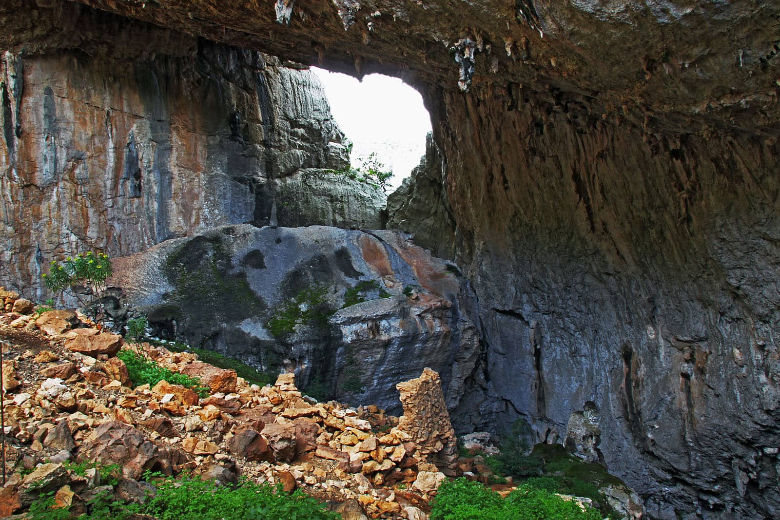
Vid Pogacnik, CC BY-SA 4.0, Wikimedia Commons (https://commons.wikimedia.org/wiki/File:Tiscali_archaeological_site.jpg)
Tiscali, the Nuragic village hidden in the Supramonte between Dorgali and Oliena: what it is, what we know, how to hike there and what to check first.
The Nuragic village of Tiscali is a truly unusual archaeological site: a settlement built inside a huge sinkhole, hidden inside a Supramonte mountain on the border between the territories of Dorgali and Oliena. This guide explains what it looks like, what we know (and don't know) about its history, how to get there and how to prepare for a visit that, unlike many others, takes some stamina and a lot of caution.
In brief
- Tiscali stands on Monte Tiscali (about 500 metres), in the Lanaittu valley, on the border between the Supramonte of Dorgali and that of Oliena.
- It is built inside a doline (sinkhole) created when the roof of a cave collapsed. You cannot see it from outside.
- You can only get there on foot, on a demanding hike; Sardegna Turismo and Italia.it advise against improvising, and the Dorgali and Cala Gonone tourism portal says the visit is allowed only with an authorised guide.
- Entry is paid. Hours and prices change: always check with the operator before you go.
Where is Tiscali and which municipality does it belong to?
Tiscali is in central-eastern Sardinia, in the province of Nuoro, inside Monte Tiscali, a little over 500 metres high. Sardegna Turismo places it between the Supramonte of Oliena and that of Dorgali; the Region's archaeological sheet describes it on the summit of the mountain, in the Lanaittu valley, in a commanding position on the right of the Rio Sa Oche. The site therefore lies on the border between Dorgali and Oliena: that is why you find starting points from both towns. According to Italian Wikipedia, which cites a 2017 article in La Nuova Sardegna, about 90% of the site's territory belongs to Dorgali and the remaining 10% to Oliena; the regional sources simply speak of a border, which is the wording we use too.
To get your bearings: on one side is the Lanaittu valley, rougher, on the Oliena side; on the other the gentler Oddoene valley, where the Flumineddu stream carved the Gorropu gorge. Gorropu, careful, is something else: according to Sardegna Turismo the gorge marks the border between Orgosolo and Urzulei, and one of the three trails to it starts from Dorgali. We cover it in our guide to Gorropu Gorge; for an overview of the area there is our guide to Dorgali and Cala Gonone.
A village inside a sinkhole
What strikes you most is the position. The village occupies a karst doline, a large truncated-cone depression formed when the roof of a cave chamber collapsed. The dwellings are built against the walls of the cavity and are invisible until you enter through a large opening in the rock. Today the debris from the collapse is colonised by holm oak, juniper, ash, wild olive, mastic and fig.
According to Sardegna Turismo the settlement has two groups of dwellings:
- in the north, about forty huts, round and oval, with thin walls, once roofed with a tholos vault or branches; the doorways had juniper lintels and inside you can see niches and storage recesses;
- in the south-west, about thirty smaller houses, square or rectangular.
The two building phases show in the masonry: the older, Nuragic one uses dry-stone walls with medium and large stones; the later one uses small stones bound with mortar and is attributed, cautiously, to indigenous people in contact with the Romans. The Region's sheet instead speaks of huts of modest size, with circular and elongated oval plans, mostly collapsed, built of barely roughed-out local limestone rubble. One hut still has a wooden lintel at its entrance.
The place also has a practical advantage that explains the choice: the doline shelters from sun, wind and rain, and is cool in summer and milder in winter. A large window opened in the wall allowed the valley to be watched; today it gives a view. An inner path runs along the edge of the doline, beside a drop of about 200 metres: a good reason to walk with care.
How old is it? What the sources say (and don't say)
Honesty matters here: the dates depend on the source.
- Sardegna Turismo gives the 15th–8th century BC for the first Nuragic phase, a Roman-era rebuild and occupation into the early Middle Ages.
- The Region's sheet (Sardegna Cultura) reports that the material collected in the 1999 and 2003 excavations and in surface collections belongs to the Nuragic Middle Bronze Age (16th–14th century BC), the Iron Age (9th–6th century BC) and the Roman period (2nd–1st century BC).
- Italia.it only says that the visit takes you back «more than thirty-five centuries».
For a reader, the summary is this: a settlement used at several moments, from Nuragic times until at least the Roman phase, with an origin that is still partly unclear. In the sources we consulted there are no precise figures on the number of inhabitants or the length of each phase, and we distrust anyone who gives them.
Rebels' refuge or shepherds' village?
For decades Tiscali was told as the last refuge of the Sardinians against the Roman conquest. This reading comes from the first scholars: according to the Region's sheet, Ettore Pais visited the site in 1910, when it was still in excellent condition, and Antonio Taramelli in 1927; both interpreted it as a refuge for the Sardinians during the Roman conquest. The site was already known and visited by the shepherds of Dorgali and Oliena.
Sardegna Turismo also recalls the historical backdrop: the Ilienses (the page quotes Cicero: «emerged from underground like ants») are said to have resisted with ambushes and raids on weapons and food from the Roman mansiones. The same page reports a legend: a few archers at the narrow entrance could have stopped a whole legion. It is, precisely, a legend.
More recent studies, however, propose another interpretation. According to the Region's sheet, the evidence points to a civil settlement, with dwellings, storerooms and animal pens, tied to the agro-pastoral use of the Lanaittu valley and nearby plateaus; the doline would have been chosen for its natural shelter from bad weather and summer heat. Sardegna Turismo adds that the building technique points to a temporary, discontinuous use of the site and its position to a refuge for long periods. The two readings do not exclude each other: a shepherds' village can become a hideout in hard times.
There is one last sad note: the Region's sheet says that decades of neglect and looting have significantly damaged the site. That is why nothing should be touched or taken away.
How to get there: the two trails
Tiscali can only be reached on foot. Italia.it calls it a «demanding» trek and advises against improvising; Sardegna Turismo describes two main climbs.
From the Dorgali side. You walk from the Sa Barva bridge along the Flumineddu to the steep scala di Surtana (Surtana staircase), which leads to the summit.
From the Oliena side. You start from the Su Gologone spring and drive to the Lanaittu valley; from there you climb a steep, uneven path, an old charcoal-burners' trail, for about an hour and a half, partly along a ledge to be walked in single file. The Su Gologone spring, let's remember, is in Oliena, not in Dorgali.
At the top, a fissure in the rock is the only entrance to the doline: the village appears suddenly.
Good to know: Sardegna Turismo's page also gives the driving route to the Lanaittu valley from Dorgali (SS 125, then SP 38, SP 46 and the signs for Su Gologone/Lanaittu). Check the route on your navigation and local signs.
Guided visit, tickets and hours
The sources do not say exactly the same thing, so here is who says what. Sardegna Turismo says entry is paid and, like Italia.it, recommends relying on experienced guides. The Dorgali and Cala Gonone tourism portal is firmer: it writes that access is exclusively on foot, that the visit is regulated and allowed only with an authorised guide, and that tickets are bought inside the site, in cash, because there is no internet signal in the area. The page shows no date (the site's public data show it was last modified on 13 April 2026): always check with the tourist office or the operator before you go and, if in doubt, arrange the visit with a guide.
The Cooperativa Ghivine writes on its website that it has offered guided visits in the archaeological area since December 1995, every day of the year and with a guide always present, and that it also looks after custody of the site; it also publishes hours and fares. This information can change (the page shows no date and, according to the server data, was last modified in May 2021), so we do not quote it here: check directly with the operator or on the Italia.it page.
If you prefer an organised guided excursion, local operators that mention Tiscali on their own websites include the Cooperativa Ghivine and Orientale Sarda Escursioni: always ask what is included (guide, ticket, any transport) and the difficulty level.
Safety and preparation
This is a walk in mountain terrain, not a stroll. Before you set off:
- Suitable clothing and hiking shoes with a good sole: Sardegna Turismo recommends suitable clothing and describes the trail as steep and rough.
- Plenty of water (Sardegna Turismo tells visitors to carry water supplies) and some food.
- Avoid the hot hours in summer: it is a mountain climb and the heat makes it harder. Autumn, mild winter days and spring are more comfortable; short days, though, mean starting early to get back in daylight.
- Check the weather: in rain or mud a steep, rough trail like the one Sardegna Turismo describes can become more slippery.
- Keep away from the edges of the doline: the inner path runs beside a drop of about 200 metres.
- Tell someone your route; the single European emergency number is 112. Mobile signal can be missing in the mountains.
- Do not touch or take anything: the site has already been looted.
If you have no experience of long trails or do not feel sure, turn back or choose a guide: no photo is worth the risk.
What to combine with Tiscali nearby
If you have two days, Tiscali combines well with other places in the Supramonte. Sardegna Turismo mentions nearby the Su Gologone spring, the Gorropu gorge, the Nuragic village of Sa Sedda 'e sos Carros in the Lanaittu valley and Serra Orrios, just outside the valley. In Dorgali, the Civico Museo Archeologico holds the finds of the area (according to the tourism portal, including amphora fragments found at Tiscali) and is a good way to understand the context before walking; Serra Orrios is a village-sanctuary that the same portal lists as visitable with a guide: an alternative for those who prefer not to take on the Tiscali trek.
For information on the area and events you can also consult the website of the Comune di Dorgali.
A curiosity: according to Wikipedia, the telecom company Tiscali took its name from the archaeological site.
When to go
The sources we consulted do not name a recommended season; common sense does. Spring and autumn are the most balanced: milder temperatures and daylight still long enough. In summer the heat makes the climb tiring and it is better to start early. In winter the risk is not heat but short days, mud and changeable weather.
After a day of dust and trail, the sea awaits you in Cala Gonone: if you want a shaded spot at Palmasera, see the sunbed and umbrella rental or the prices.
Frequently asked questions
Is Tiscali in Dorgali or Oliena?
The sources speak of a border: the village stands on Monte Tiscali, between the Supramonte of Dorgali and that of Oliena, in the Lanaittu valley. According to Italian Wikipedia about 90% of the site's territory belongs to Dorgali and the rest to Oliena. You can reach it from either side.
Can you visit Tiscali on your own?
Sardegna Turismo and Italia.it advise against improvising and recommend experienced guides, and the Dorgali and Cala Gonone tourism portal writes that the visit is regulated and allowed only with an authorised guide. Entry is paid: for current rules, hours and prices, ask the site operator or the tourist office.
How hard is the hike to Tiscali?
It is a demanding trek. From the Oliena side Sardegna Turismo gives about 1.5 hours of climbing from the foot of the mountain, on a steep, uneven path, partly along a ledge to be walked in single file; from the Dorgali side you walk along the Flumineddu and then climb the steep Surtana staircase.
How old is the village of Tiscali?
According to Sardegna Turismo the first Nuragic phase runs from the 15th to the 8th century BC, followed by a Roman-era rebuild and occupation into the early Middle Ages. The Region's own sheet on the recovered material points to the Middle Bronze Age, the Iron Age and the Roman period: dates depend on the source.
What does the telecom company Tiscali have to do with it?
According to Wikipedia, the company took its name from the archaeological site. Otherwise it has nothing to do with your visit.
From the area: businesses mentioned in this article
Editorial mentions with verified official links; any commercial partnership is marked with a “Sponsored” label. If you run one of these businesses and want the entry corrected or removed, write to us.
Tours and guides · Cala Gonone
Cooperativa Ghivine
Cooperative founded in 1991 in Dorgali: hikes and treks in the Supramonte, archaeological itineraries and sea outings.
Tours and guides · Dorgali
Orientale Sarda Escursioni
Excursion centre based in Dorgali: hiking in the Supramonte, kayaking on Lake Cedrino and in the Gulf of Orosei.
Sources and further reading
- Sardegna Turismo — Villaggio nuragico di Tiscali
- Sardegna Cultura — The village of Tiscali: an important archaeological and natural context
- Italia.it — Nuragic village of Tiscali
- Sardegna Turismo — Dorgali
- Cooperativa Ghivine — Tiscali (operator of the guided visits)
- Wikipedia — Tiscali (village)
- Wikipedia — Tiscali (sito archeologico), Italian edition
- Dorgali Gonone — Archaeological sites (Dorgali and Cala Gonone tourism portal)
Keep reading
Hiking · October 25, 2026 · 13 min read
Gorropu Gorge: how to get there and what to know first
A canyon cut into the limestone of the Supramonte, between Urzulei and Orgosolo: how to reach it on foot, what sources say on tickets and guides, and why rain changes everything.
Read the article →
The area · October 9, 2026 · 12 min read
What to See in Dorgali and Cala Gonone: A Guide to the Area
A mountain town facing the sea, a seaside village on the Gulf of Orosei and a hinterland of gorges, caves and nuragic villages: how to find your way and what not to miss.
Read the article →
Sea and beaches · October 25, 2026 · 10 min read
Pink Beach near Cala Gonone? Where It Really Is, What to See
The famous Pink Beach is on Budelli, in the La Maddalena archipelago, and landing is not allowed. Where to see it properly and what is pinkish at Cala Gonone.
Read the article →